Detail View: Selections from the David Rumsey Map Collection II: Imperial Airways Map of Empire & European Air Routes.
|
Short Title:
|
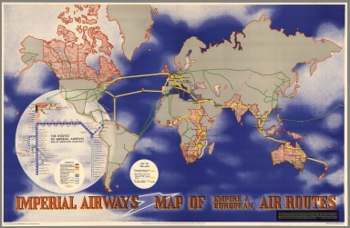
Imperial Airways Map of Empire & European Air Routes.
|
|
Obj Height cm:
|
65
|
|
Object Width cm:
|
101
|
|
Note:
|
This extraordinary world map by noted Bauhaus designer and artist, Laszlo Moholy-Nagy, draws on the pioneering information design work of Harry Beck and his London subway maps, here used to show the routes of Imperial Airways and associated airlines. What is special about the map is the combining of the more standard world map with air routes shown, with the abstract version in Beck's style of the entire route system, in an overlaid diagram floating above the Americas and the southern Pacific ocean. To further complicate the design, Moholy-Nagy uses Stanford maps with their more standard map conventions to delineate the countries that made up the British empire in 1937. The remainder of the world is left abstract. This is a very unusual map and very rare. Moholy-Nagy's name is not printed on the map, but the attribution comes from Borchardt-Hume, "Albers and Moholy-Nagy: From the Bauhaus to the New World," 2006 Tate Publications, London. Clearly shows the British Empire and air routes. Inset shows frequency of service and miles from London for Europe, Africa, Asia and Australia/New Zealand.
|
|
Reference:
|
Borchardt-Hume, "Albers and Moholy-Nagy: From the Bauhaus to the New World," 2006, Tate Publications, London, p.58.
|
|
Full Title:
|
Imperial Airways Map of Empire & European Air Routes. ... Published by Imperial Airways Ltd. I A/P/61-1M 4/37.
|
|
List No:
|
8717
|
|
Series No:
|
1
|
|
Pub Date:
|
1937
|
|
Pub Title:
|
Imperial Airways Map of Empire & European Air Routes. ... Published by Imperial Airways Ltd. I A/P/61-1M 4/37.
|
|
Pub Note:
|
This extraordinary world map by noted Bauhaus designer and artist, Laszlo Moholy-Nagy, draws on the pioneering information design work of Harry Beck and his London subway maps, here used to show the routes of Imperial Airways and associated airlines. What is special about the map is the combining of the more standard world map with air routes shown, with the abstract version in Beck's style of the entire route system, in an overlaid diagram floating above the Americas and the southern Pacific ocean. To further complicate the design, Moholy-Nagy uses Stanford maps with their more standard map conventions to delineate the countries that made up the British empire in 1937. The remainder of the world is left abstract. This is a very unusual map and very rare. Moholy-Nagy's name is not printed on the map, but the attribution comes from Borchardt-Hume, "Albers and Moholy-Nagy: From the Bauhaus to the New World," 2006 Tate Publications, London. Clearly shows the British Empire and air routes. Inset shows frequency of service and miles from London for Europe, Africa, Asia and Australia/New Zealand.
|
|
Pub List No:
|
8717
|
|
Pub Maps:
|
1
|
|
Pub Height cm:
|
65
|
|
Pub Width cm:
|
101
|
|
Image No:
|
8717000.jp2
|
|
Publisher:
|
Imperial Airways Ltd.
|
|
Publisher Location:
|
London
|
|
Type:
|
Separate Map
|
|
World Area:
|
World
|
|
Engraver or Printer:
|
Curwen Press Ltd.
|
|
Pub Type:
|
Separate Map
|
|
Date:
|
1937
|
|
Filename:
|
8717000.jp2
|