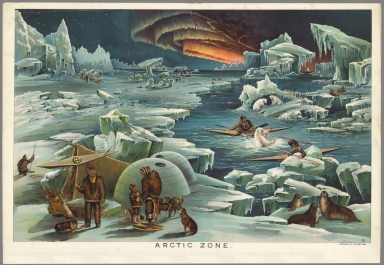
Detail View: Selections from the David Rumsey Map Collection II: Arctic Zone.
|
Short Title:
|
Arctic Zone.
|
|
Obj Height cm:
|
56
|
|
Object Width cm:
|
86
|
|
Scale 1:
|
none shown
|
|
Full Title:
|
Arctic Zone.
|
|
List No:
|
10096.005
|
|
Series No:
|
5
|
|
Pub Date:
|
1893
|
|
Pub Title:
|
Yaggy's Geographical Portfolio
|
|
Pub Note:
|
Yaggy's large geographical charts are among the most beautiful and impressive educational charts published in the 19th century. Using chromolithography, Yaggy created stunning colors and contrasts in his images of the world, its regions, and peoples. The ten charts in this set were originally housed in a large wooden portfolio that also served as a display mechanism, allowing the charts to be tilted up for classroom use. In the portfolio were also two elaborate charts of the universe with moving parts and tinted gels. In 1887 Yaggy published a set of charts with a similar theme, "Geographical Study: Comprising Physical, Political, Geological and Astronomical Geography," although it did not include any of the chromolithographic charts in our 1893 set. Rather it had more conventional maps of the world and nations. Yaggy intended his charts to be used in classrooms by students, and issued a teacher’s handbook to assist with instruction. Yaggy published other educational works: Museum of Antiquity; A Description of Ancient Life… (1880); The Royal Path of Life; Or, Aims and Aids to Success and Happiness (1881); The Standard History of All Nations and Races… (1899); and How to Do a Consulting Library for Every Want (1902); Yaggy’s Anatomical Study; Presenting the Skeleton, Muscles, Arteries, Veins and Nerves, also Four Life-Size Manikins of the Body, the Head, the Eye and the Ear (Chicago, ca. 1884-1885), which featured life-size illustrations and cutaways of the human body.
|
|
Pub List No:
|
10096
|
|
Pub Maps:
|
10
|
|
Pub Height cm:
|
56
|
|
Pub Width cm:
|
86
|
|
Image No:
|
10096005.jp2
|
|
Publisher:
|
C.F. Rassweiler & Co.
|
|
Publisher Location:
|
Chicago
|
|
Type:
|
Atlas Map
|
|
Pub Type:
|
Physical Atlas
|
|
Date:
|
1893
|
|
Filename:
|
10096005.jp2
|