Detail View: Selections from the David Rumsey Map Collection I: Comparative Heights of the Principal Mountains and Lengths of the Principal Rivers.
|
Filename:
|
00020049.jpg
|
|
Identifier:
|
3362071.jpg
|
|
Title:
|
Comparative Heights of the Principal Mountains and Lengths of the Principal Rivers.
|
|
Creator:
|
Darton, William; Gardner, W.R.
|
|
Subject:
|
Mountains and Rivers
|
|
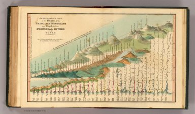
Description:
|
This may be the earliest chart to depict the heights of mountains and the lengths of rivers together in one illustration, with the rivers hanging down over the mountains. Wolter says that Bulla's Tableau Comparatif of 1826 is the earliest of the combined mountain and river type, but he had not seen this chart by Gardner done three years earlier and does not list it. This chart is beautifully done and, while not large in size, it is impressive in its scope. Full color. Map is mounted on linen, dissected into 8 sections with an end sheet label reading "The Most Approved Modern Maps, Plans, And Charts, Of every Description, From The Best Authorities, Constantly on Sale at William Darton's Map, Print, and Chart Warehouse, 58, Holborn Hill, London..." Map folds into a dark green marbled cardboard case with a turquoise paper label printed with the map title (as above); there is a "William Darton's, Map seller" bookplate label on the back of the case.
|
|
Publisher:
|
William Darton
|
|
Contributor:
|
David Rumsey Historical Map Collection
|
|
Date:
|
1823
|
|
Language:
|
English
|
|
Rights:
|
Cartography Associates
|