Detail View: Selections from the David Rumsey Map Collection I: Maine vertical sections.
|
Filename:
|
3441004.jpg
|
|
Identifier:
|
3441004.jpg
|
|
Title:
|
Maine vertical sections.
|
|
Creator:
|
Greenleaf, Moses, 1777-1834
|
|
Subject:
|
Mountains and Rivers
|
|
Description:
|
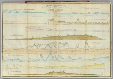
Ten engraved sections on sheet. Hand col. Horizontal scale 10 miles to an in.; vertical scale 2000 ft. in an in. Contents: no. 1. Northern boundary along the highlands dividing the waters of the St. Lawrence from those of the Atlantic -- no. 2. From the great northern ridge to Mars Hill, dividing the waters of Penobscot & St. John -- no. 3. Comparative inclination of St. Johns, Penobscot & Kennebeck Rivers -- no. 4. Inclination of the Aroostook for 110 miles from its mouth. Odells survey -- no. 5. Eastern boundary. Bouchette's survey 100 miles and Odell & Johnsons continuation -- no. 6. From the sea near Harpwell due north to the northwestern boundary -- no. 7. From Thomaston north to the northern boundary -- no. 8. From Frenchman's Bay, north -- no. 9. Road from Hallowell to Quebec. Capt. Partridge's survey -- no. 10. From the northwest boundary nearly east to the sources of the St. Croix.
|
|
Publisher:
|
Shirley & Hyde Portland
|
|
Contributor:
|
David Rumsey Historical Map Collection
|
|
Date:
|
1829
|
|
Type:
|
Atlas Map
|
|
Language:
|
English
|
|
Rights:
|
Cartography Associates
|