Detail View: Selections from the David Rumsey Map Collection I: World in Hemispheres.
|
Identifier:
|
3007001
|
|
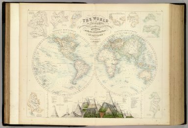
Title:
|
World in Hemispheres.
|
|
Creator:
|
Fullarton, A. & Co.
|
|
Subject:
|
Mountains and Rivers
|
|
Subject:
|
Map
|
|
Description:
|
1st edition 1864; published in 27 parts 1854-62. The date of 1872 is estimated by the Australia map; all the maps are undated and probably date throughout the period 1864 to 1872: the North America map shows Colorado and Russian America while the United States map has no Colorado. The World maps show Alaska. This is the last highly decorative atlas published in England. Even the maps without views or figures are beautifully engraved and colored with a mixture of printed color and hand color. Swanston, Petermann, Bartholomew, Macnab and Johnson engraved the maps. The introduction by Shaw among other things lists important general atlases published over a long period. He lists only one United States atlas, Mitchell's Universal Atlas of 1853! The maps bear a superficial resemblance to Keith Johnston's Royal Atlas. Fullarton frequently gives the sources for his maps - for the United States maps he gives Calvin Smith and Tanner as sources. The atlas is bound in half leather dark green cloth covered boards with "The Royal Illustrated Atlas." stamped in gilt on the cover; the spine reads "Royal Illustrated Atlas" in gold.
|
|
Publisher:
|
A. Fullarton & Co. London and Edinburgh
|
|
Contributor:
|
David Rumsey Historical Map Collection
|
|
Date:
|
1872
|
|
Type:
|
Atlas Map
|
|
Rights:
|
Cartography Associates
|