Detail View: Selections from the David Rumsey Map Collection II: Map Of the Diving Ducks Eiders and Mergansers of North America
|
Short Title:
|
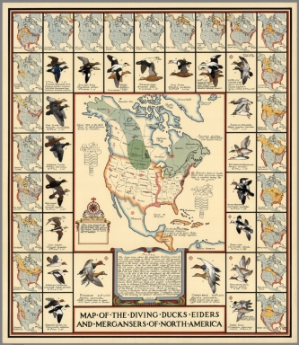
Map Of the Diving Ducks Eiders and Mergansers of North America
|
|
Obj Height cm:
|
76
|
|
Object Width cm:
|
65
|
|
Scale 1:
|
25,000,000
|
|
Note:
|
Outline colored pictorial map. Shows countries and states. Various illustration of wild birds, with symbols referring to the size, length, weight, etc. of each species, framed the map of North America. The entire map is bordered with 23 small maps of North America showing the breeding and concentration of fowl in each area. Notes: "The large map show the important breeding areas for wild fowl remaining in North America, and the principal concentration areas. The maps in connection with the various panels in the border show the breeding areas in yellow and and the boundaries of the fall and wither ranges by red lines. The red arrows show the probable migration routes from breeding to winter areas ... Includes acknowledgment. and notes; "This edition limited to One thousand copies of which this is number".
|
|
Full Title:
|
Map, of, the, Diving, Ducks, Eiders and Mergansers, of, North, America. This map designed by Richard E. Bishop and Joseph P. Sims. Copyright 1937.
|
|
List No:
|
8123
|
|
Pub Date:
|
1937
|
|
Pub Title:
|
Map, of, the, Diving, Ducks, Eiders and Mergansers, of, North, America. This map designed by Richard E. Bishop and Joseph P. Sims. Copyright 1937.
|
|
Pub Note:
|
See note field above.
|
|
Pub List No:
|
8123
|
|
Pub Height cm:
|
76
|
|
Pub Width cm:
|
65
|
|
Image No:
|
8123000.jp2
|
|
Publisher:
|
Bishop & Sims
|
|
Publisher Location:
|
Indianapolis, Ind.
|
|
Type:
|
Separate Map
|
|
World Area:
|
North America
|
|
Pub Type:
|
Separate Map
|
|
Date:
|
1937
|
|
Filename:
|
8123000.jp2
|